


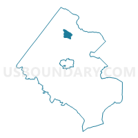
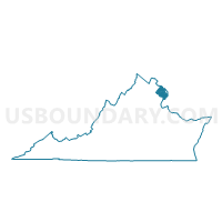
Colvin Voting District, Fairfax County, Virginia
About
Outline

Summary
| Unique Area Identifier | 681608 |
| Name | Colvin Voting District |
| County | Fairfax County |
| State | Virginia |
| Area (square miles) | 3.03 |
| Land Area (square miles) | 3.01 |
| Water Area (square miles) | 0.02 |
| % of Land Area | 99.36 |
| % of Water Area | 0.64 |
| Latitude of the Internal Point | 38.96173990 |
| Longtitude of the Internal Point | -77.29420490 |
Maps

Graphs
Select a template below for downloading or customizing gragh for Colvin Voting District, Fairfax County, Virginia


Neighbors
Neighoring Voting District (by Name) Neighboring Voting District on the Map
- Aldrin Voting District, Fairfax County, VA
- Forestville Voting District, Fairfax County, VA
- Hickory Voting District, Fairfax County, VA
- Kenmore Voting District, Fairfax County, VA
- Reston #2 Voting District, Fairfax County, VA
- Shouse Voting District, Fairfax County, VA
- Sunrise Valley Voting District, Fairfax County, VA
- Westbriar Voting District, Fairfax County, VA
- Wolftrap Voting District, Fairfax County, VA
Top 10 Neighboring County Subdivision (by Population) Neighboring County Subdivision on the Map
- Hunter Mill district, Fairfax County, VA (128,052)
- Dranesville district, Fairfax County, VA (114,174)
Top 10 Neighboring Place (by Population) Neighboring Place on the Map
- Reston CDP, VA (58,404)
- McLean CDP, VA (48,115)
- Wolf Trap CDP, VA (16,131)
- Great Falls CDP, VA (15,427)
Top 10 Neighboring Unified School District (by Population) Neighboring Unified School District on the Map
Top 10 Neighboring State Legislative District Lower Chamber (by Population) Neighboring State Legislative District Lower Chamber on the Map
- State House District 35, VA (87,326)
- State House District 34, VA (74,627)
- State House District 36, VA (74,325)
Top 10 Neighboring State Legislative District Upper Chamber (by Population) Neighboring State Legislative District Upper Chamber on the Map
Top 10 Neighboring 111th Congressional District (by Population) Neighboring 111th Congressional District on the Map
Top 10 Neighboring Census Tract (by Population) Neighboring Census Tract on the Map
- Census Tract 4803, Fairfax County, VA (7,105)
- Census Tract 4819, Fairfax County, VA (5,567)
- Census Tract 4820.01, Fairfax County, VA (4,801)
- Census Tract 4804.01, Fairfax County, VA (4,526)
- Census Tract 4601, Fairfax County, VA (4,286)
- Census Tract 4602, Fairfax County, VA (3,973)
- Census Tract 4824, Fairfax County, VA (2,378)